GEOSPATIAL DATA PRESENTATION FORM: vector, downloadable data, ArcGIS Geodatabase
PROCESSING ENVIRONMENT: Microsoft Windows 7 Version 6.1 (Build 7601) Service Pack 1; Esri ArcGIS 10.2.2.3552
SPATIAL REFERENCE PROJECTION: NAD_1983_Idaho_TM
REFERENCE SYSTEM IDENTIFIER: ESRI - 102605
Description:
The Portneuf.gdb GIS data is a package of downloadable data for use in research.
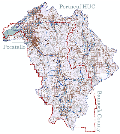
As can be seen by the list, there are various levels of Hydrologic Unit Code Boundaries, several stream networks at different scales, water bodies (lakes, reservoirs, etc.), Bannock County Boundary, streets and other products that are part of the National Hydrography Dataset.
The NHD contains reach codes for networked features, flow direction, names, and centerline representations for areal water bodies. The NHD also incorporates the National Spatial Data Infrastructure framework criteria established by the Federal Geographic Data Committee. The names and definitions of all feature types, characteristics, and values are in the Standards for National Hydrography Dataset: Reston, Virginia, U.S. Geological Survey, 1999. The document is available online through https://nationalmap.gov/standards/.
Use and Access Constraints:
None. Acknowledgment of the originating agencies would be appreciated in products derived from these data.
Citation Information, Originator:
U.S. Geological Survey in cooperation with U.S. Environmental Protection Agency, USDA Forest Service, and other Federal, State and local partners as well as U.S. Census Bureau.
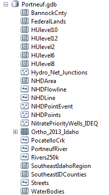
Click on image to download ...