MILES Managing Idaho's Landscapes for Ecosystem Services

Impacts of the urban-rural changes in Boise and Portneuf basins


Idaho State University Participants

Donna Lybecker, Mark McBeth, Katrina Running, Yolonda Youngs

Partners and Affilation

Monica Hubbard at BSU, Tim Frazier at UI, Graduate capstone class in Public Administration at BSU, Courtney Thompson (graduate student at UI)

Research Problem

Assess the societal and ecological implications of the changing boundaries for urbanized areas in the Boise River and Portneuf River basins (Ada, Canyon and Bannock Counties, Idaho). Documentary and survey research aided in gaining a more comprehensive understanding of the historic and current trends associated with the urban-rural landscape changes and give stakeholders and the public an image of possible future scenarios, allowing them to evaluate how they want change to progress.

Research Outcomes

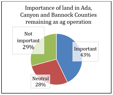
To accomplish this, we used documentary research to construct the historical and current conditions (maps) of the Boise River and Portneuf River Basins. We then developed a survey and sent it to 3000 agrarian landowners, identified through US Census parcel data along with a data from the North American Industry Classification System (NAICS). The survey asked about land ownership, economic conditions and willingness to sell, support for agricultural policies in Idaho, and connections to community, along with demographic questions. We had 868 responses to the survey. Data was analyzed and results were assessed and combined with historical and current conditions information. The results from the survey allowed us to depict trends in urban-rural land use, boundary changes, and incorporate projections for future urbanization. In particular we found lack of connection to land is an important determinant of willingness to sell agricultural lands for development (taking the land out of agriculture) whereas a strong connection to the land made land owners less willing to sell for non-agricultural purposes.

Potential Impacts

Understanding trends in urban-rural land use and urban/rural boundary changes allow for projections for future urbanization patterns. This work has the potential to help determine where to target conservation measures—maintaining agricultural lands. It also shows the importance of connection to land, in particular cultural connections through groups such as the Shoshone Bannock tribe. This increased understanding of connection to land can help create better working relationships with these groups. Finally, this research involved cooperation and coordination between faculty and students at ISU, BSU, and U of I, creating stronger research relationships and training / giving students experience in survey collection and development pattern research within Idaho.


Additional Information
Lybecker, Donna, Mark McBeth, Monica Hubbard, Tim Frazier. “Agricultural Land Use and Place Connectedness: Empirical Findings and Policy Implications” Under review at Journal of Rural Studies.

Structure and function of streams across gradients of development
and stream flow permanence in the Portneuf River watershed


Idaho State University Participants

Rebecca Hale, Carolyn Macek

Partners and Affilation

Hannah Sanger - City of Pocatello

Research Problem

Within Pocatatello urban stormwater is an important challenge and major cause of aquatic ecosystem degradation, largely through effects on hydrologic patterns and water quality. The objective of this work is to understand how patterns of urban stormwater quality and quantity vary across a gradient of urban development and stream flow permanence in Pocatello, ID.

Research Outcomes

Example: To accomplish this, we will instrument urban watersheds in the Pocatello, ID area with automated water samplers that will collect stream water samples during rainfall-runoff events and during snowmelt. These measurements will be paired with measurements of discharge and rainfall depth. Samples will be analyzed for total suspended solids, particulate organic matter, nitrate, ammonium, phosphate, dissolved organic carbon, and total dissolved nitrogen. Concentrations and loads of these materials will be compared across sites, and relationships between hydrology and water quality will be compared across sites.

Potential Impacts

This research will fill a critical gap in the urban stream and urban stormwater literature, which currently does not address patterns in cold desert ecosystems and has few examples of studies on temporary streams. Furthermore, while there are many urban stream studies in areas with significant snowfall, the seasonal aspect of urbanization’s effects on hydrology and water quality has only been explored at the broadest levels. This research is also of local significance since these watersheds will fall under the City of Pocatello’s stormwater management permit. Detailed research on urban stormwater in Pocatello is welcomed by local managers and will be used to better understand the local challenges and opportunities for stormwater management.

Quantifying the Sustainability of Urban Growth and Form through Time:
An Algorithmic Analysis of a City’s Development


Idaho State University Participants

Jared Ogle, M.S. and Donna Delparte, PhD.

Partners and Affilation

Hannah Sanger - City of Pocatello

Research Problem

To discern the sustainability of Pocatello’s past growth and current urban form, so that policy makers can make data based decision for planning future growth and managing ecosystem services, various data reflecting changes in urban growth and metrics have been developed to quantify change in sustainability over time in Pocatello

Research Outcomes

To accomplish this, we have coordinated with members of the city and county to collect data depicting present day Pocatello, and with the help of aerial photography reconstructed urban form: built extent, building footprints, and transportation infrastructure of Pocatello on a decadal basis from 1941 until today. Utilizing this data along with population and household data we have constructed algorithms that quantify various aspects of sustainability and form, giving an overall sustainability score for the city for every decade studied. The output from these show various trajectories of growth over the past 75 years and how changes in urban form have affected the sustainability of Pocatello.

Potential Impacts

An understanding of how past growth choices effect the sustainability of Pocatello and how its built footprint utilizes one of the most important ecosystem resources, the land itself, can give decision makers in Pocatello the power to evaluate how changes in the cities growth utilize natural capital. Aspects of the city such as, lot size, dwelling unit types, which are all effected by city policy choices can show how past policy has effected the cities sustainability. Beyond Pocatello, the python-based algorithms can be utilized by other cities’ planners and policy-makers with data and layers available to almost every municipality.

Figure 1 - Intersection density is indicative of block size and has been shown to have a positive correlation to population. As the city of Pocatello has grown away from old town seen mostly in red and orange, density of intersections has decreased. Table 1. Indices for density, compactness, and clustering, as well as, the composite metric of the three, overall sustainability of form. Higher scores indicate more sustainable metrics, and all have been indexed relative to the present day

Water scarcity across watershed Social-Ecological Systems (WaterSES)
within the Program for Ecosystem Change and Society (PECS)


Idaho State University Participants

Antonio J. Castro, Colden V. Baxter, Cristina Quintas-Soriano, Sara Bernardini, Dainee Gibson, Katrina Running, Sarah Godsey, David Rogers, Donna Lybecker, Rebecca Hale

Research Problem

WaterSES is an interdisciplinary group working to understand and compare the social-ecological dynamics causing and caused by water scarcity in three very different watersheds, with the goal of finding sustainable solutions to balance the water needs of nature and society. Three place-based pilot study areas – arid southern Spain, the Ouachita Mountains and Gulf Coastal Plains ecoregions of Oklahoma (US), and two watersheds of Idaho (US) – have different climates, water needs and socio-ecological dynamics, but are all experiencing new regional, societal demands for limited water resources. The goal of this working group is to study the social-ecological dynamics of three water-limited systems to propose sustainable water use solutions.

Research Outcomes

The goal of this working group is to understand the socio-ecological systems dynamics in watersheds, and how such dynamics can be influenced by water scarcity and conflicting local and regional water needs. We will use an ecosystem services framework to a) characterize the coupled human-nature interactions and derived societal impacts of each social-ecological system, b) quantify the biophysical capacity to supply water-related ecosystem services, c) characterize the societal demand for water-related ecosystem services, d) explore trade-offs and synergies between supply of and demand for ecosystem services, and f) engage the general public and institutional and political dimensions to propose solutions for sustainable water use. Members of our trans-disciplinary team have backgrounds in ecology, hydrology, political science, sociology, physical and human geography, history, public policy, urban planning, computer sciences, communication and visualization.

Potential Impacts

The PECS-WaterSES project is crucial to be able to compare SES dynamics causing, and caused by, water scarcity in diverse sites across the world -- in Spain, Oklahoma and Idaho. The PECS-WaterSES is a unique opportunity to bring Idaho onto the international SES stage.